Decker Mountain
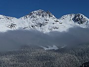
Mountain in the country of CanadaDecker Mountain is a 2,421-metre (7,943-foot) flat-topped peak located in the Garibaldi Ranges of the Coast Mountains, in Garibaldi Provincial Park of southwestern British Columbia, Canada. It is part of the Spearhead Range, which is a subset of the Garibaldi Ranges. It is situated 9 km (6 mi) southeast of Whistler, and 3.9 km (2 mi) west-northwest of Tremor Mountain, which is the highest point in the Spearhead Range. Precipitation runoff from the south side of the peak drains into Fitzsimmons Creek which is a tributary of the Cheakamus River, and meltwater from the Decker Glacier on the northeastern slope drains to Wedge Creek.
Read article


Top Questions
AI generatedMore questions
Nearby Places
Blackcomb Glacier Provincial Park
Provincial park in British Columbia, Canada
Blackcomb Peak
Mountain in British Columbia, Canada

The Spearhead
Peak in the Garibaldi Ranges of British Columbia, Canada

Spearhead Range
Spearhead Glacier
Glacier in British Columbia, Canada

Horstman Glacier
Glacier in British Columbia, Canada

Mount Trorey
Mountain in the country of Canada

Phalanx Mountain
Summit in Garibaldi Provincial Park of British Columbia, Canada